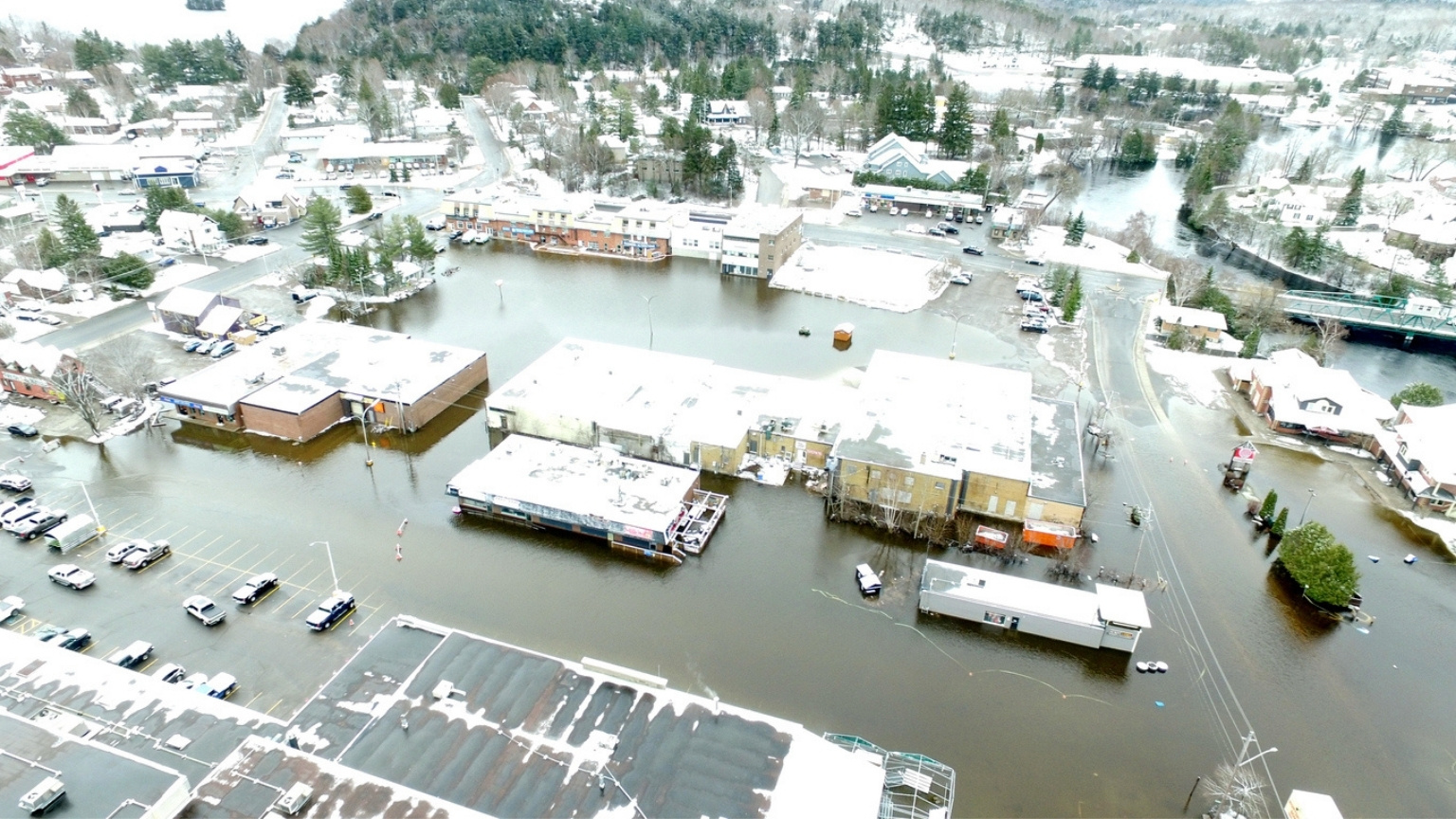
With the arrival of spring, places across Ontario are experiencing severe flooding. While residents in the Muskoka region fill sandbags to prepare, others in Sudbury are doing the same under a state-of-emergency. From Sault Ste. Marie to the Ottawa River, rising water levels and warming temperatures are combining for dangerous conditions.
We reached out to Paulin Coulibaly, a professor in the Department of Civil Engineering and the School of Earth, Environment & Society, to talk about how engineers are working to safeguard Canadians during floods. Coulibaly launched FloodNet five years ago to fast-track the modernization and standardization of hydrologic modelling, flood forecasting, monitoring and mitigation systems across the country and recently received funding to continue the project.
1. Why are areas like Muskoka experiencing flooding right now?
Some areas like the Muskoka River watershed are experiencing flooding now because in addition to the common spring flood drivers like rainfall on melting snow or rapid increase of temperatures leading to fast snowmelt on still frozen soil, the watershed’s physical characteristics can exacerbate the flooding. Muskoka is a good example of areas where watershed characteristics play an important role in the flooding.
2. How are rivers and lakes interacting to make this so severe?
The watershed is dominated by a complex network of streams, cascading shallow lakes and water management structures (e.g. dams, navigation locks). Recall that water moves from high to low elevation. Most of the lakes in the Muskoka watershed are shallow with limited storage capacity to drawdown water to mitigate flooding. In the spring, due to freshet — a rapid rise in a river’s water level, usually caused by rain or melting snow — water level is high in the lakes which causes streamflow to back up, creating a backwater effect that exacerbates the flooding. Furthermore, existing dams were not initially designed for flood control, therefore their use for flood mitigation is limited.
3. How can people best prepare for future floods?
To be better prepared for future floods, people should be first adequately informed about the increasing risks of living in flood prone areas. Sound information allows people to consider possible mitigation actions at the municipal, community and individual level. Effective actions can be taken at the municipal and provincial level, such as building flood defense structures (levees, dikes, diversion channels, small dams, etc.). Implementing an effective flood early warning systems (FEWS) is essential for mitigating flood impacts. At the individual level, flood mitigation actions are limited, but people in flood prone areas should have an emergency plan, have flood insurance and advocate for flood defense structures.
4. How would you explain how FloodNet works to a five-year-old?
It is difficult to believe that FloodNet is already older than a five-year-old! Bringing experts from government and academia to work with industry to enhance our capacity to deal with floods, has been proven to be the best approach in this area. Such collaborative work is time consuming but yields useful results. Over the last five years, FloodNet has made significant contributions to operational flood forecasting across Canada. Most of the provincial flood forecasting centers are now using advanced forecasting systems, which was not the case five years ago. While FloodNet1 focused on the forecast of river floods and the socioeconomic impact of floods across Canada, in the next four years, FloodNet2 will focus on urban flash floods across Canadian large cities and flood protection structures.
5. How does being a civil engineer affect how you approach flood research?
My approach to flood research is mostly driven by the desire to find practical solutions to deal with floods, which is in general how engineers tackle problem. In academia, however, this involves the training of qualified engineers to help society to better deal with the increasing flood events. Early warning systems are important, but designing and building new flood protection infrastructure is critical for flood prone areas of the country. A good example is the Winnipeg Red River floodway that has protected the city for decades. In the next four years, one of the 10 research projects of FloodNet2 will focus on analysing critical flood defense structures across Canada. This project, led by researchers from the Department of Civil Engineering, will use drone technology and GIS tools to assess the structural risk of failure and cascading effects under extreme flood events.